
1. Introduction
In June 2020, the DGCA published its draft Unmanned Aircraft System Rules, 2020, which envisages the establishment of an Unmanned Aircraft Traffic Management (UTM) System, and sets the stage for Beyond Visual Line of Sight (BVLOS) operations in India. Many countries1 around the world have begun implementing UTM systems to facilitate basic drone traffic management services, so that drones can operate within the existing air traffic environment in their national airspace.
Our previous post had examined the global regulatory framework for BVLOS operations and given certain recommendations for operationalising BVLOS flights in India. In this post, we analyse the regulatory framework for UTM systems in the U.S. (Part 2), and Europe (Part 3). Part 4 concludes with suggestions for the Directorate General of Civil Aviation (DGCA), on issues regarding detailed operation planning, risk assessment, pilot testing, industry collaboration, and communication.
The International Civil Aviation Organisation (ICAO) has set out a Common Framework for UTMs globally, laying out core principles for harmonisation. It defines UTM as a "a specific aspect of air traffic management which manages UAS operations safely, economically and efficiently through the provision of facilities and a seamless set of services in collaboration with all parties and involving airborne and ground-based functions." This definition has been entirely adopted by the DGCA in its Draft Rules.2
Another way of understanding a UTM system for drones is to look at its enabling technologies and the functions they serve:3
- Drone identification and registration - to allow airspace managers to identify and communicate with each drone flying in the airspace, and to identify a rogue drone.
- Pre-flight management, airspace management, flight management tool - to give an accurate and up to date picture of the airspace, including data on obstacles, other drones, weather etc. This includes geo-fencing and automatic/instantaneous flight approvals.
- Collision avoidance (for obstacles and other drones) - in the form of a sense-and-avoid system
- Communication - to ensure real time communication between the drone and its operator and the airspace manager to enable the flight manager to dynamically alter the drone trajectory in case of unforeseen emergencies.
- Navigation - to allow drones to navigate themselves with precision in all conditions, and to comply with airworthiness standards.
2. UTM Systems in the U.S.
The Federal Aviation Authority (FAA) has adopted a "traffic management ecosystem", namely the Unmanned Aircraft System Traffic Management or UTM to provide a supporting framework to facilitate multiple BVLOS operations at low altitudes (under 400 feet above ground level).4 Consequently, the UTM system in the U.S. aims to identify the relevant data exchange protocols, information architecture, communications and navigation, sense and avoid, software functions, infrastructure, performance requirements, and roles and responsibilities for various stakeholders
The UTM is separate from, and complementary to, FAA's Air Traffic Management System since it is focused on the management of low altitude 'uncontrolled' drone operations, where FAA air traffic services do not run. This takes place through cooperative interaction between the FAA and drone operators to communicate real-time airspace status, using the frameworks provided in the Research Transition Team plan, the Low Altitude Authorization and Notification Capability (LAANC), and the Concept of Operations document.
2.1 Research Transition Team plan
The Research Transition Team (RTT), set up through the collaborative effort between FAA and NASA in 2017, is meant to coordinate the UTM initiative by researching complex UTM operational scenarios and technologies and demonstrating their capability on the NASA UTM research platform.5
The scope and objectives of the UTM RTT till September 2020 include:
- Conducting research, development, and testing to identify the requirements for airspace operations that will enable large scale VLOS and BVLOS operations in low-altitude airspace. This will transpire through collaboration across government agencies, collaboration with industry, and through using the UTM research platform for simulations and tests.
- Using "build a little test a little" strategy so that drone operations can eventually transition from remote to urban areas. Such a strategy will help understand airspace constraints and how the solutions can be scaled.
- Technology transfers from the UTM RTT to the FAA and industry that can provide insight for airspace design and geo-fencing, separation management, weather and wind avoidance, routing, and contingency management for low altitude drone operations. These insights will be in the form of services, roles, data exchange protocols, information architecture,6 and software and performance requirements for drone operations that can support multiple coordinated BVLOS operations; and BVLOS and manned operations.
- Technology transfers from the UTM RTT to the FAA on flight information management prototypes, including relevant algorithms, software prototype etc.
The RTT focused on four sub-groups (i) concept and use cases; (ii) data exchange and information architecture; (iii) communication and navigation; and (iv) sense and avoid. For each of these subgroups, the UTM RTT established specific goals and objectives, timelines for compliance, and the activities to be covered.
2.2. LAANC
Another instance of FAA and industry cooperation is the FAA UAS Data Exchange through LAANC7 which automates the application and approval process for airspace authorisation. Here, remote pilots (under the sUAS Part 107 or recreational flyer exception rules) can apply to get near real time authorisation for drone operations in low altitude controlled airspace near airports and an awareness of where they can or cannot fly. By further facilitating data exchange and supporting air traffic control authorisation requirements, the LAANC programme represents an important step in the integration of drones in the U.S. airspace.
The FAA has published a YouTube video on how to apply for airspace authorisation using LAANC. The FAA emphasises the importance of LAANC as providing the capability to access the controlled airspace under 400 feet and to share airspace data between it and companies approved to provide the LAANC capability. One such company, approved as a drone service supplier for LAANC is AirMap that allows users to request for airspace authorisation using its 'AirMap for Drones' app. A list of air traffic facilities participating in LAANC has been published by FAA on its website.8
2.3 Version 2.0 Concept of Operations: UTM operational framework
In March 2020, the FAA released Version 2.0 of the UTM Concept of Operations (V2.0 ConOps), which was a product of the collaborative efforts between different offices within the FAA, NASA, and industry stakeholders, including BVLOS operators. It documents the continued maturation of UTM through use case development, rulemaking insights, and the evolution of UTM Technology Capability Level and Pilot Program demonstrations.
V2.0 ConOps prescribe the following operational UTM framework that provides the requisite support for the safe conduct of drone operations:
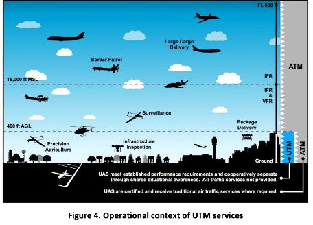
- Participation: Drone operators that do not receive separation services from air traffic control have to participate in the UTM system based on the location of their proposed operations and performance requirements. This can be seen from the following screenshot in V2.0 ConOps which divides the airspace into areas receiving UTM services and traditional air traffic management services.
- Performance authorization - to ensure that all operator performance requirements are fulfilled. This is necessary because all drones significantly differ in their communication, navigation, and surveillance performance; and thus, a common understanding has to be evolved amongst the actors to ensure the safe operation of drones. UTM operators have to obtain a performance authorization from the FAA before conducting drone operations, to satisfy it that they can meet the flight performance capabilities in the intended area of operation.
- Airspace authorization - needed for operations that take place within controlled U.S. airspace. All drone operators conducting UTM operations within the controlled airspace (Classes B, C, D, and E)9 require FAA authorization. The authorization can be for a specific location or a broad area covered by the air traffic control's jurisdiction and is for a limited duration of time - usually less than 24 hours. Operators can apply for airspace authorization either through FAA's DroneZone or LAANC.
- Operation planning - which supports the sharing of flight intent to help situation awareness. An operation plan (in contrast to a flight plan) provides details such as the 4D volume of airspace where the operation will take place;10 and the time and location of key events like launch, recovery etc. These plans are shared with other drone service suppliers to ensure fair and safe access to the airspace by preventing overlaps in the airspace between planned drone operations.
- Dissemination of near real time information - about airspace constraints and traffic, weather data, and information about unexpected obstacles such as cranes or bird activity. The identification of such unexpected operational conditions and flight hazards helps promote safe drone operations.
- De-conflicting operations - through the use of services and technologies to ensure separation of UTM operators from other aircraft, airspace, weather, hazards, and for generally avoiding unsafe conditions during an operation. Shared intent, shared awareness, vehicle tracking, and procedural right of way rules also helps in ensuring this separation.
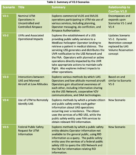
This operational framework is deployed in the following five scenarios in V2.0 ConOps, which are described in great detail in the document:
2.4 Allocation of responsibilities
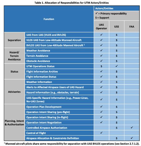
V2.0 ConOps summarizes the role and responsibilities of the drone operator (UAS Operator), drone service supplier (USS),11 and the FAA associated with the UTM operation through the following table:
2.5 Integrating BVLOS operations within the UTM
The FAA updated its Concept of Operations document to expand the operational scenarios to include more complex cases such as BVLOS operations in controlled airspace.12
Since BVLOS operators cannot rely exclusively on information exchange with the FAA, tasks such as identifying and separating themselves from VLOS operations and manned aircraft, have been entrusted to the BVLOS drone operators and drone services suppliers.
Consequently, BVLOS operators must use UTM services for the purposes of:
- Registration
- Airspace authorization
- Identification of nearby drone operators for data exchange
- Remote ID transmission to ensure accountability and traceability for BVLOS operations since the operator and the drone are not co-located.
- Strategic de-confliction by sharing flight intent, and monitoring compliance with it. In complex BVLOS operations taking place in higher density areas, real time avoidance equipment such as detect and avoid technologies may also have to be employed.
- Sharing operation intent (including operation volume of the intended flight path) with other drone operators and airspace users through the USS network.
- Notifications and alerts for in-flight conflict or in flight re-route; and
- Weather surveillance and navigation.
In contrast, VLOS operators do not require data exchange with other UTM participants in order to visually separate themselves from other drones and manned aircraft.
V2.0 ConOps plays out a detailed scenario (Scenario V2-1 mentioned in the table above) where multiple BVLOS, VLOS, and drone operations over people are scheduled in the Southwest quadrant of Cleveland Hopkins International Airport spanning over the Class B and G airspace. These drone operations are meant for package delivery, photography, agriculture spraying, training, and construction and rail inspections. The FAA then elaborates on the varied considerations that have to be taken into account in the operation planning phase, flight phase, and landing and post-flight phase to ensure the safe flight of all the drone operations.
2.6 Vision for UTM
The FAA expects UTM capabilities to be implemented incrementally over the next few years.13 However, it has already commenced operations through a UTM Pilot Project where certain providers have been selected to develop and demonstrate a traffic management system to safely integrate drone flights in low altitude airspace within the US airspace system.
FAA's vision for UTM is that "airspace will be managed to enable multiple drone operations conducted BVLOS, where air traffic services are not provided." To achieve this goal, FAA expects "cooperative interaction" between drone operators and itself to communicate real time airspace status.14 Conversely, however, when it comes to the role of state and local authorities in helping the FAA manage its airspace, especially in use cases such as managing corridors for package delivery or hyper local drone restrictions for wildfires or accidents on the highway, the FAA has not provided many details.
3. BVLOS operations in Europe
In March 2020, the European Union Aviation Safety Agency (EASA) published Opinion No. 01/2020 on the High Level Regulatory Framework for the U-Space to create and harmonise the necessary conditions for manned aircraft and drones to operate safely in the U-space airspace; to prevent collisions between these aircraft; and to mitigate the air and ground risks. This Proposal is expected to be adopted by the Commission in the final quarter of 2020.
U-space is Europe's unmanned air traffic management framework meant to help integrate drones into the airspace. EASA defines U-space as the "set of services provided in an airspace volume designated by the Member State to manage a large number of UAS operations in a safe and efficient manner."15
The U-Space Opinion is the first step towards establishing a pan-European regulatory framework for the deployment of a UTM system, which will support the safe development of drone operations, in low altitude airspace through the adoption of proper safety risk mitigation measures and processing of flight authorisation requests.
EASA aims to achieve these objectives through the sharing of information about where and how high drone operators can fly, the status of the airspace volume in which they intend to fly, information about other traffic that may be conflicting with their planned trajectories, and weather and wind information.
3.1 Risk-based approach
The U-space Opinion follows a risk-based approach to establish a framework to classify drone operations and reduce the risk of collisions between manned and unmanned aircraft. For instance, it highlights the importance of a common information service and common information service provider that will facilitate the exchange of important information between the drone operators, U-space service providers (USSPs), the air navigation service providers (ANSPs) and all the other participants in the U-space airspace.
EASA also designates four U-space services as mandatory in the U-space airspace to ensure safe operations, namely network identification, geo-awareness, traffic information, and flight authorisation. Member states have the flexibility of designating certain other U-space services as additionally necessary - for instance, weather services for drones that operate in an area with known hazardous wind or temperature factors.
To further mitigate risks, the EASA draft proposal imposes the following requirements on drone operators:
- Determining where U-space airspace is designated, and then executing a contract with a certified USSP (who provides the mandatory set of U-space services in that airspace) of their choice.
- Submitting flight authorisation request forms to the contracted USSP and operating according to the authorisation conditions.
- Complying with the USSP's instructions along with ensuring that the drones are technically capable of receiving the U-space services; and are capable of operating in the U-space airspace.
3.2 Establishing a level playing field and competitive market
The U-space Opinion also seeks to foster the development of the market in the EU by ensuring a level playing, and competitive, field so as to encourage investment in the drone market and the U-space services market. To this end, EASA seeks to establish common data exchange protocols and a cooperative environment that encourages seamless information exchange (especially regarding aircraft operators' positions, drone operators' intent, operational constraints, and data relevant for safety).
In addition to ensuring safety, designating the four U-space services (network identification, geo-awareness, traffic information, and drone flight authorisation) as mandatory promote competitiveness. Each drone operator will receive the same services and have the same interface with the USSP in order to operate in any U-space airspace across Europe. The harmonisation of the services provided by USSPs will lay the groundwork for an enforceable pan-European framework that will result in the growth of the U-space services market.
EASA has clarified that if additional U-space services are required (such as tactical de-confliction service) with the maturation of the market, it will propose the requisite amendments.
3.3. Integrating BVLOS operations within the U-space
EASA views the U-Space as the 'enabler' to manage BVLOS operations with the requisite safety, security, privacy, and efficiency considerations.16 Given the nascent stage of development of detect and avoid systems and sense and avoid systems, EASA is of the opinion that the only way to ensure safe BVLOS operations in the U-space airspace is through the sharing of real time information by drone operators about their actual position in the airspace. If that is not possible, then EASA will have to ensure segregation of the airspace (i.e. allocate specified dimensions of the airspace for exclusive use to a specific user). Currently, individual countries have segregated their airspace to facilitate BVLOS operations, which results in a more complex European airspace, thus creating greater difficulty for general aviation operations.
EASA acknowledges that till full integration of the airspace used by manned aircraft and drones is possible, the focus should be on mitigating air and ground risks.
3.4 Future vision
After considering various options, EASA concluded that the preferred option is that of developing a harmonised framework for the establishment of U-space across Europe (rather than at the national level), with continuous monitoring and evaluation about the implementation
The U-space opinion is the first step in facilitating more complex drone operations in the future such as the transportation of passengers and regular cargo or package deliveries within an urban environment.
Although Europe currently does not have a harmonised U-space framework, individual member states have been regulating drones through national UTM frameworks. For instance, Belgium, Denmark, Austria, Switzerland, Poland, Finland, Italy, Spain and France have implemented U-space services of static geo-awareness and flight authorisation. In 2019, Antwerp-based start-up Unifly NV, which provides UTM software for drones, received ?17 million Series B round funding for further investment in this sector.17 Germany is scheduled to launch integrated drone detection system trials at its largest airports in August 2020, based on the partnership between the German regulator, the German air navigation service provider (DFS) and the Ministry of Transport.18 In May 2020, Droniq, a joint venture between DFS and Deutsche Telekom launched the first fully operational UTM in Germany that showed manned and unmanned air traffic in a combined air situation display.19
4. Conclusion
Existing air traffic management systems (for manned flights) are human-centric and will not be capable of managing a large volume of unmanned and automated drone operations, especially BVLOS operations, which have distinct flying characteristics from manned aircraft.20 Although the draft UAS Rules, 2020 released by DGCA envision the establishment of UTM in the Indian airspace, they do not provide any details or clarity regarding the proposed UTM. The DGCA can take the following lessons from the steps taken by the US and the EU regulators in how to design UTM systems in a safe, efficient, and acceptable manner:
- Detailed operational scenario planning - The DGCA can, like the FAA, can use detailed distinct scenarios where multiple drone operations are taking place, to lay out the parameters to be followed during an operational and safety assessment. Within such operational plans, a risk-based assessment approach should be adopted.
- Lay the building blocks of the UTM framework like the EASA - by identifying certain UTM services that are essential, such as geo-awareness, traffic information and data exchange, network identification, and drone flight authorization.
- Pilot projects and repeated testing - The DGCA needs to continually evolve UTM technology through pilot projects and repeated testing, like the FAA and the German regulators.
- Institutionalize industry collaboration so that there is a better understanding of how BVLOS operations can be conducted within the UTM framework by focusing on parameters for drone registration, airspace authorization, identification of nearby drone operators for data exchange, sharing flight intent and monitoring compliance with it, and weather surveillance.
- Communication: The DGCA should speak to regulators such as the FAA and EASA from around the world to learn from their learnings regarding UTM systems and how to better integrate the lower altitude airspace occupied by drones with the controlled airspace being used by manned aircraft. Issues of coordination amongst federal and local authorities; how to ensure exchange of information amongst UTM service providers; or whether, and how, future providers of real time situational awareness information will exchange data are complex, and the DGCA may benefit from regular communication with other regulators.
Authored by the Ikigai Law team with inputs from Rakesh Vohra from Unifly.
Footnotes
1. A map of international UTM implementation can be found here.
2. The draft Rules define UTM as "a specific aspect of air traffic management which manages UAS operations safely, economically and efficiently through the provision of facilities and a seamless set of services in collaboration with all parties and involving airborne and ground-based functions." They further define UTM System as a "system that provides traffic management for unmanned aircraft through the collaborative integration of humans, information, technology, facilities and services, supported by air, ground or space-based communications, navigation and surveillance."
3. The elements that make up a UTM system, https://www.unmannedairspace.info/wp-content/uploads/2018/02/UTM-concept-and-roadmaps.v1.pdf.
4. FAA, Unmanned Aircraft System Traffic Management (UTM), https://www.faa.gov/uas/research_development/traffic_management/
5. UTM Research Transition Team Plan, 2017, https://www.faa.gov/uas/research_development/traffic_management/media/FAA_NASA_UAS_Traffic_Management_Research_Plan.pdf
6. As per the RTT plan, this would require the development of protocols and guidelines that will allow information exchange between operators; between operators and the national air space/air traffic management systems; and between operators, drone service suppliers, and air navigation support providers..
7. FAA, UAS Data Exchange (LAANC), https://www.faa.gov/uas/programs_partnerships/data_exchange/
8. FAA, Air traffic facilities participating in LAANC, https://www.faa.gov/uas/programs_partnerships/data_exchange/laanc_facilities/.
9. The US airspace is divided into controlled and uncontrolled airspace and the level of services provided by the FAA differ based on the airspace class. Controlled airspace includes Classes A, B, C, D, and E, with Class A being the highest (from 18,000 feet mean sea level, up to and including flight level 600) and Class E being the lowest. Uncontrolled airspace is Class G, which extends from the surface to the base of the overlying Class E airspace. Remote pilots do not require ATC authorization to fly in Class G airspace, although some visual flight rules apply there. The ATC does not provide services to drones operating under 400 feet above ground level. See FAA, Concept of Operations, v2.0 UTM, https://www.faa.gov/uas/research_development/traffic_management/media/UTM_ConOps_v2.pdf.
10. The operation volume is divided into the three spatial dimensions along with time, that allows drone service suppliers (USS) to de-conflict operations where possible. Operation volumes are 4D shapes with specified floor and ceiling that include an operator's flight profile within an authorized area of operation. They can take a variety of forms such as 4D discs, tubes, or complex shapes. See FAA, Concept of Operations, v1.0 UTM, https://utm.arc.nasa.gov/docs/2018-UTM-ConOps-v1.0.pdf.
11. A USS is an entity that helps the drone operator with meeting the UTM operational requirements that will facilitate the safe and efficient use of airspace.
12.FAA, Concept of Operations, V2.0, UTM, supra note 9.
13. FAA, DOT UAS Initiatives, https://www.faa.gov/uas/programs_partnerships/DOT_initiatives/
14. FAA, Unmanned Aircraft System Traffic Management, https://www.faa.gov/uas/research_development/traffic_management/
15. EASA, Opinion No. 01/2020 on the High Level Regulatory Framework for the U-Space. The U-Space includes the digital infrastructure, services, and procedures to support safe and efficient access to drones within the lower airspace.
16. EASA, High Level Regulatory Framework for the U-Space, Opinion No. 01/2020, https://www.easa.europa.eu/sites/default/files/dfu/Opinion%20No%2001-2020.pdf.
17. Philip Smith, Unifly raises $19.3 m for unmnned drone traffic management platform, Dronebelow, 04 July 2019, https://dronebelow.com/2019/07/04/unifly-raises-19-3m-for-unmanned-drone-traffic-management-platform/
18. Jenny Beechener, Germany plans national drone detection trials at select airports later this year, Unmanned Airspace, 18 June 2020, https://www.unmannedairspace.info/uncategorized/germany-plans-national-drone-detection-trials-at-selected-airports-later-this-year/
19. Droniq launches UTM System in Germany, UAS Vision, 28 May 2020, https://www.uasvision.com/2020/05/28/droniq-launches-utm-system-in-germany/
20. EASA, Opinion No. 01/2020 on the High Level Regulatory Framework for the U-Space.
Originally published 8 October, 2020
The content of this article is intended to provide a general guide to the subject matter. Specialist advice should be sought about your specific circumstances.

