
Following a series of moderate (Mw4.0-6.3) earthquakes across north-western Japan during 2023, this year started with a shallow Mw7.5 earthquake off the coast of the Noto peninsula. WTW Research Network summarises the key details.
Technical details
The earthquake struck at 07:10 UTC (16:10 local time, JST) on Monday 1st January 2024, 7km north-west of Suzu and 30km north-east of the city of Wajima, located on the Noto Peninsula of Ishikawa Prefecture, Japan. According to the USGS, the epicentre was located at 37.50°N 137.24°E, at a depth of 10km. The event occurred along a moderately dipping ~150km long reverse-fault striking to the north-east, along the convergent boundary between the Amurian and Okhotsk Plates. The largest event has a moment magnitude of Mw7.5, and highest Modified Mercalli shaking intensity (MMI) of IX (violent) centred around and to the south-west of the epicentre. Peak Ground Acceleration exceeded 1g (Peak Ground Velocity >1m/s) where these high MMI intensities were reported (Figure 1).
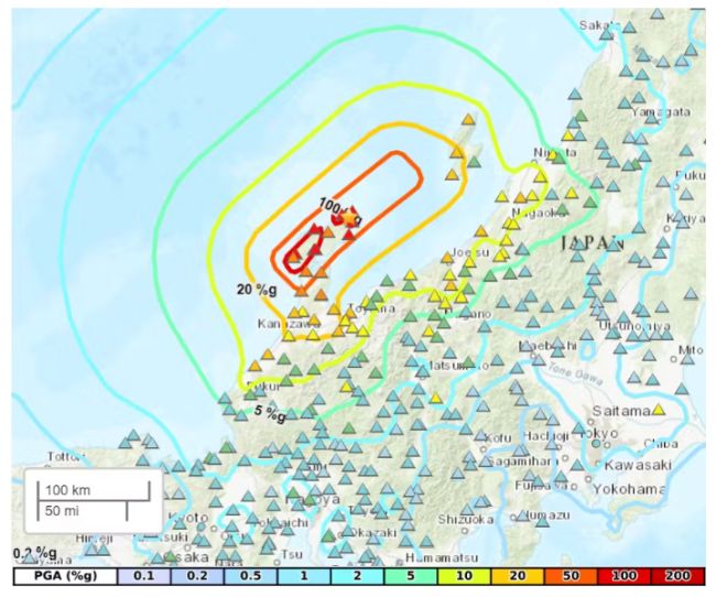
Figure 1: Peak Ground Acceleration.
Source: USGS
WRN partner Temblor Inc. reports several lower magnitude earthquakes occurred during 2023 (Mw≥4.0, with the largest being Mw6.3 on the 5th May), part of a seismic swarm of >20,000 events and ground uplift recorded since November 2020 (Amezawa et al. 20231, Kato 20232). A Mw5.5 foreshock occurred approximately four minutes prior to the Mw7.5 event, and more than 50 aftershocks of Mw≥4.0 were noted in the following seven days. The largest of these was Mw6.2, occurring ~45km to the south-west of the mainshock and 8 minutes later. The USGS estimates a maximum slip of ~3.5m along the fault, mostly to the south-west of the epicentre where the highest intensities and many subsequent aftershocks were reported.
50+
aftershocks of Mw≥4.0 were noted in the following seven
days.
Mw6.2
largest occurring ~45km to the south-west of mainshock 8
minutes later
Due to the coastal location of the earthquake, a major tsunami warming was issued for the Noto peninsula and further advisory warnings were issued along much of the west coast (Figure 2). Tsunami waves were reported to reach heights of 1.2m near the city of Wajima, according to the Japan Meteorological Agency, and a research team from the National Building Research Institute and the University of Tokyo modelled wave heights as high as 3.6m in the prefectures of Ishikawa and Suzu. The Earthquake Research Institute at the University of Tokyo found sections of coastline in western Japan had shifted up to 250m towards the sea in some places. The quake was also reported to have caused widespread landslides, and liquefaction in coastal areas to the south of the epicentre.
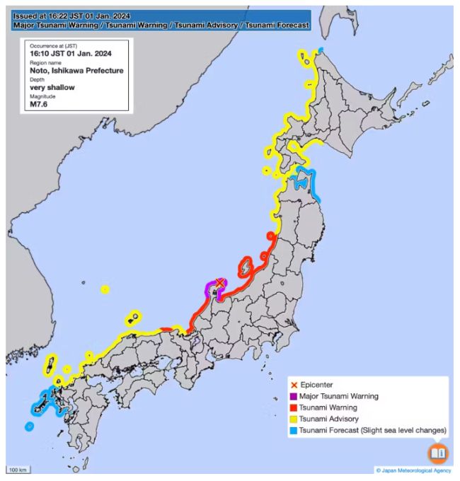
Figure 2: Tsunami warnings issued on 1st January 2024.
Source: Japan Meteorological Agency.
Human and infrastructure loss details
A combination of earthquake shaking and tsunami waves resulted in widespread damage to buildings and infrastructure, with Japan's Fire and Disaster Management Agency (FDMA) reporting more than 3,500 properties as damaged as of the 11th January. This value had risen to as high as over 22,000 homes damaged, and more than 15,000 partially or completely destroyed by the 17th January. Secondary perils added to this value, with a fire in the city of Wajima destroying more than 200 shops and homes and landslides causing further infrastructure damage.
Japan's Fire and Disaster Management Agency (FDMA) reported :
3,500+
properties damaged by 11th January
22,000
homes damaged, and more than 15,000 partially or
completely destroyed by 17th January.
Local news agencies have reported the death toll to be 232 as of the 17th January, with over 1,100 injured and 20 still missing. This correlates with the lower end of estimated fatalities projected by the USGS's 'Prompt Assessment of Global Earthquakes for Response' (PAGER) system. The USGS estimates that approximately 43,000 people were exposed to the strongest MMI IX (violent) shaking, and the GEM Foundation report 30,000 people whose housing conditions were affected by the event (including loss, damage and displacement).
The insurance industry has estimated that losses will be up to JPY870 billion (US $6 billion), which includes damages from secondary impacts such as fire, tsunami, landslide, and liquefaction-induced ground movement. Most of this total is expected to come from residential dwellings, as Ishikawa prefecture is primarily a residential area. The final number may end up being higher as early estimates do not include infrastructure losses, such as transportation and utilities.
Footnotes
1. Amezawa, Y., Hiramatsu, Y., Miyakawa, A., Imanishi, K., & Otsubo, M. (2023). Long-living earthquake swarm and intermittent seismicity in the northeastern tip of the Noto Peninsula, Japan. Geophysical Research Letters, 50, e2022GL102670.
2. Kato, A. (2024). Implications of fault-valve behaviour from immediate aftershocks following the 2023 Mj6.5 earthquake beneath the Noto Peninsula, central Japan. Geophysical Research Letters, 51, e2023GL106444.
The content of this article is intended to provide a general guide to the subject matter. Specialist advice should be sought about your specific circumstances.
